Humorous maps of Europe in 1870
What's the first thing that comes to mind when you hear the word “map”? Most of us would probably think of road maps. There are, however, many different kinds of maps, ranging from maps of historical events and time periods to maps of plant and animal habitats, maps of the moon and stars, and even maps of places that exist only in our imagination. Our latest blog post features two humorous maps from the Rare Book Collection.
 Since at least the eighteenth century, artists have used Europe’s geographic features to evoke national characteristics (or, more often, cultural stereotypes). Good examples of this are the two maps shown here. They were published in Berlin during the Franco-Prussian War of 1870-71, a brief but bloody conflict in which the German kingdom of Prussia defeated France and sowed the seeds of resentment that eventually led to World War I.
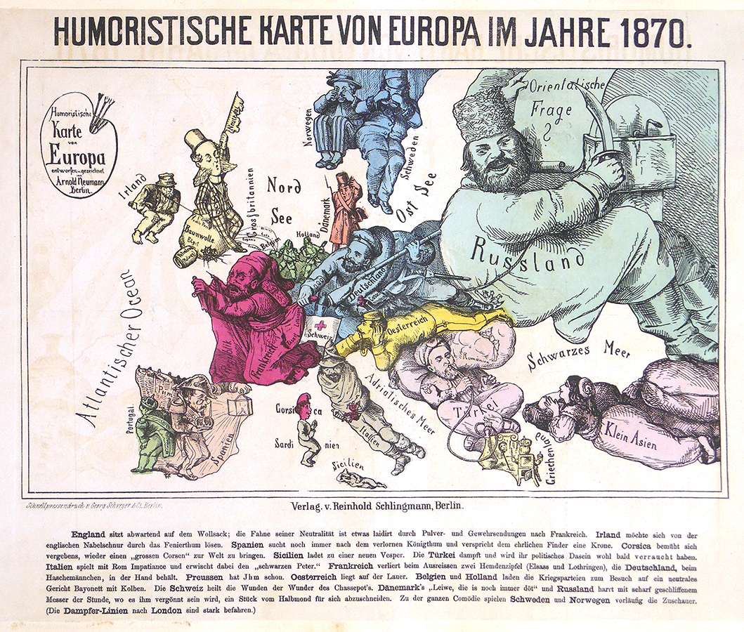
The French emperor, Napoleon III, was unpopular and received no aid from other European countries, some of which thought the war might work to their advantage. England is shown here as detached and aloof, with its “slave” (Ireland) on a chain. Sweden and Norway watch from afar with binoculars. Russia is sharpening a blade and eyeing the Balkans, which, although mostly Slavic, were still part of the Ottoman Empire (represented by a man with a hookah). Italy is characterized as one of Giuseppe Garibaldi’s revolutionaries, crushing the pope in Rome. Austria, recently defeated by Prussia, lies flat on its belly watching the scene unfold, while Prussia grabs the French by their coattails.
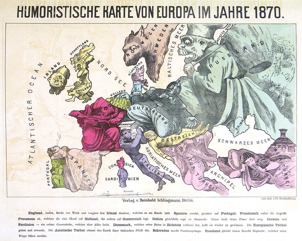
 A second, related print makes the same point. England turns a blind eye to the conflict. Spain and Turkey sit idly by, smoking. A corpse-like Austria-Hungary is being kneed in the chest by a husky German soldier, while the Balkans wake up with a yawn (symbolizing the move towards independence from Turkey) only to find Austria’s rear end in their face! Neutral Switzerland is a locked, snow-covered chalet.
These maps are part of a large collection of caricatures related to the Franco-Prussian War. Need a topic for a research paper or creative project? Have a look (and a laugh) at this collection! It is cataloged as Sammlung von Caricaturen, Illustrationen, und Bilder zur Geschichte des Krieges und der Revolution von 1870-1871 (Rare DC291 .S3 Flat) and De Berlin à Paris: A Collection of Prints, Sketches, Caricatures, &c., formed in Berlin during the Period of the Franco-German War, 1870-71 (Rare DC291 .D4 Flat). See also the library’s guide to published materials on the Franco-Prussian War and Paris Commune.
 Since at least the eighteenth century, artists have used Europe’s geographic features to evoke national characteristics (or, more often, cultural stereotypes). Good examples of this are the two maps shown here. They were published in Berlin during the Franco-Prussian War of 1870-71, a brief but bloody conflict in which the German kingdom of Prussia defeated France and sowed the seeds of resentment that eventually led to World War I.
The French emperor, Napoleon III, was unpopular and received no aid from other European countries, some of which thought the war might work to their advantage. England is shown here as detached and aloof, with its “slave” (Ireland) on a chain. Sweden and Norway watch from afar with binoculars. Russia is sharpening a blade and eyeing the Balkans, which, although mostly Slavic, were still part of the Ottoman Empire (represented by a man with a hookah). Italy is characterized as one of Giuseppe Garibaldi’s revolutionaries, crushing the pope in Rome. Austria, recently defeated by Prussia, lies flat on its belly watching the scene unfold, while Prussia grabs the French by their coattails.
 A second, related print makes the same point. England turns a blind eye to the conflict. Spain and Turkey sit idly by, smoking. A corpse-like Austria-Hungary is being kneed in the chest by a husky German soldier, while the Balkans wake up with a yawn (symbolizing the move towards independence from Turkey) only to find Austria’s rear end in their face! Neutral Switzerland is a locked, snow-covered chalet.
These maps are part of a large collection of caricatures related to the Franco-Prussian War. Need a topic for a research paper or creative project? Have a look (and a laugh) at this collection! It is cataloged as Sammlung von Caricaturen, Illustrationen, und Bilder zur Geschichte des Krieges und der Revolution von 1870-1871 (Rare DC291 .S3 Flat) and De Berlin à Paris: A Collection of Prints, Sketches, Caricatures, &c., formed in Berlin during the Period of the Franco-German War, 1870-71 (Rare DC291 .D4 Flat). See also the library’s guide to published materials on the Franco-Prussian War and Paris Commune.
A second, related print makes the same point. England turns a blind eye to the conflict. Spain and Turkey sit idly by, smoking. A corpse-like Austria-Hungary is being kneed in the chest by a husky German soldier, while the Balkans wake up with a yawn (symbolizing the move towards independence from Turkey) only to find Austria’s rear end in their face! Neutral Switzerland is a locked, snow-covered chalet.
These maps are part of a large collection of caricatures related to the Franco-Prussian War. Need a topic for a research paper or creative project? Have a look (and a laugh) at this collection! It is cataloged as Sammlung von Caricaturen, Illustrationen, und Bilder zur Geschichte des Krieges und der Revolution von 1870-1871 (Rare DC291 .S3 Flat) and De Berlin à Paris: A Collection of Prints, Sketches, Caricatures, &c., formed in Berlin during the Period of the Franco-German War, 1870-71 (Rare DC291 .D4 Flat). See also the library’s guide to published materials on the Franco-Prussian War and Paris Commune.The LSU Libraries includes the LSU Library and the adjacent Hill Memorial Library. Together, the libraries contain more than 4 million volumes and provide additional resources such as expert staff, technology, services, electronic resources, and facilities that advance research, teaching, and learning across every discipline.
